How To Hike The El Pianista Trail in Boquete

The El Pianista is the most notorious trail in Panama.
That’s not due to its difficulty or its scenery, but because of a tragic episode that made international headlines and continues to captivate the true crime community.
If you’re simply scouting out some hikes to do in Boquete, there’s a good chance you may not even be aware of its darker backstory - but the context is necessary.
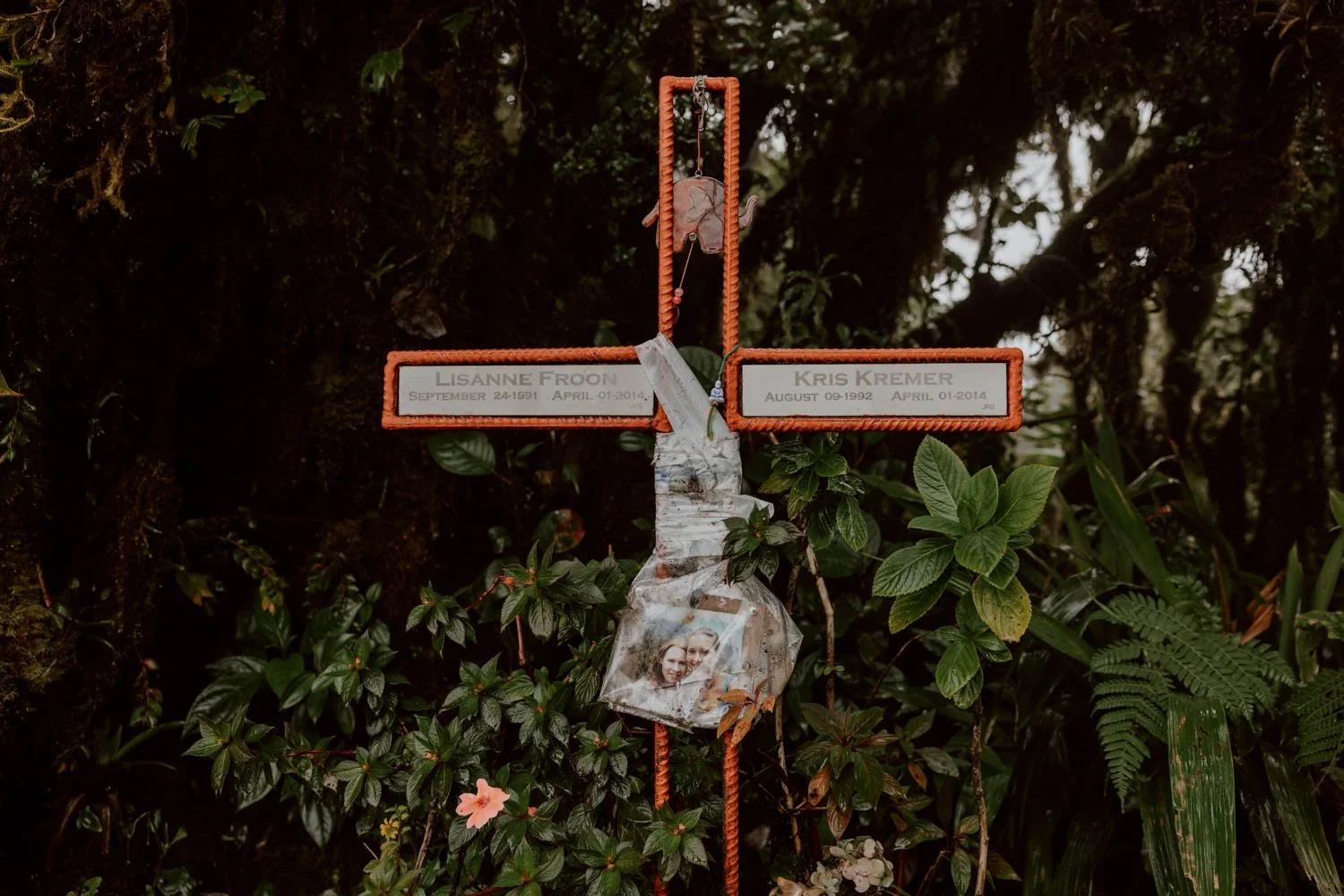
In 2014, Kris Kremers and Lisanne Froon - two young Dutch backpackers - disappeared and died in mysterious, unsettling circumstances. One of Panama’s most talked-about cases where much that’s known makes little sense, it’s riddled with mysterious photos, partial remains, confusing evidence, police incompetence, local gossip, and many unanswered questions.
The official verdict is that they got lost in this dense cloud forest for several days before dying, but the alternative narrative is that one or both were murdered.
These unsettling events loom over the trail and small highland coffee town as much the dark afternoon clouds that roll in, and from personal experience, it’s very easy to fall down a rabbit hole of podcasts, forums, and articles about it.
Fundamentally though, beyond the conspiracies and accusations, it’s a heartbreaking story of two young female travellers who never made it home - something that just shouldn’t happen on any hike or adventure.
Whilst our article isn’t going to focus in-depth on what (may have) happened after they reached the summit of El Pianista, we are going to share a few good resources at the end where you can learn more if you wish.
Instead, we’re going to do what we usually do, and share our personal insights on the hike and all the essentials to help you decide whether to include El Pianista in your Boquete itinerary, as well as plan your own hike. We’ll cover routes, conditions, transport, getting lost, what to bring, mistakes to avoid, whether you really need to go with a certain guide or not, and why you probably can’t trust your GPS.
We’ll also try to give a fair, balanced perspective on some of the fears, speculation, hyperbole that continues to give a false impression of the trail’s risks to current day hikers.
This is our guide to hiking the El Pianista, Boquete.
The El Pianista Essentials
Where / Starts 5km outside Boquete
Trail / Steep out-and-back to summit
Distance / 10km
Time / 4 to 5 hours total
Difficulty / Moderate to challenging
Cost / Free to enter
Navigation / Very poorly signposted
Know / Better to start in the morning for views
Bring / Water, snacks, downloaded route map, and layers
Route / El Pianista on AllTrails
Stay / We loved the homely guest house vibes of Gaia but Bambuda Castle is popular amongst solo backpackers. Downtown Suites is excellent for your own space but for real luxury take a looks at Valle Escondido Wellness Resort
How To Get To El Pianista From Boquete
It’s just 5km from the centre of Boquete to the trailhead start (here on Google Maps)
As we’ve discussed further in our main Boquete travel guide, the climate here means you’re best to do hikes in the morning, with anything started in the afternoon having a significant chance of being wet, chilly, and grey. This is especially important for hiking El Pianista as its summit mirador (viewpoint) is sort of the main reason to do the hike, and the consensus seems to be that getting to the top by 10am increases your chances of clear skies.
However, as we unfortunately found out, it’s still not guaranteed that you’ll have full (or any) visibility up there.
Public Transport & Taxis
Lots of backpackers take the regular colectivo from Boquete to the trailhead.
We are 100% certain that the the colectivo that says ‘Arco Iris El Bajo’ drops off at the El Pianista, and we’re pretty sure the ‘Alto Lino’ also passes by, and you can catch both on Avenida Central, the main road that passes through the town centre.
The orange bus shelter drop-off point is here on Google Maps. From there, the trailhead starts on the road to your left where there’s also the Il Pianista restaurant.
Depending on stops and how full the colectivo is, the journey time will be 10-15 minutes from Boquete.
If staying outside the town (i.e. at the popular Bambuda Castle), ask your hotel/hostel where’s the best place to stand on the roadside to hail it.
Unfortunately, as we drove our rental car out to hike, we’re not entirely certain on the best pick-up point, costs, or if other colectivos head out there, so do let us know in the comments if you find out!
Alternatively, a taxi driver will be delighted to take you to El Pianista from Boquete, and this likely works out cheaper than the colectivo if there’s a few of you. You’ll find them stationed outside Parque Central (maps) - and the price is $5 to $10 USD one-way depending on your negotiation skills. If unsure, ask your accommodation to arrange a ride on your behalf.
It’s also totally possible to walk the 5km/1 hour from Boquete from El Pianista (or back).


By Car
We had a rental car for half of our month in Panama, and it was ideal for independently exploring the fincas and trails around Boquete.
It’s a straightforward drive 10-minute drive out from the town, and we parked up on the left roadside near the start of the trail - this is the spot on Google Maps.
There’s space for a handful of cars there on gravel at the roadside, and we imagine it never gets too busy, but do try and optimise the space available for others.
By Tour
Due to its past, you will still read in places that it’s only possible to hike El Pianista with a guide: this isn’t true.
However, due to that same past, we understand that some travellers may prefer to go up there accompanied.
Similarly, some just prefer hiking with a guide and group rather than on their own, and both of us remarked on the way down that we passed more guided groups than on any other Boquete hike.
The easiest option will be to ask for a recommendation through your hostel, who will put you in contact with a local guide.
The most popular guide tour is led by an older man called Feliciano, who played a significant role in the Kremers and Froon case. He was leading a group of about 20 young backpackers up as we descended, and we met several people in Panama City that walked El Pianista with him after being recommended or put in touch via their accommodation. Prices are $30-45 per person depending on group size.
There’s a caveat though, which we’ll share this at the end of the post.
You will also be able to arrange a local guide via the various tour agencies you’ll find along Avenida Central in Boquete - if you have a positive personal recommendation, then please let us know in the comments.
Good To Know / After you’re done on the trail, we recommend heading to nearby Altieri Specialty Coffee (maps). Its modern terrace is one of our favourites cafes in the area, and their coffee is excellent. If you’re super organised, you could even pair up the hike with a tour or a formal tasting there.
If you’d like to know more about the experience of driving on a Panama road trip, then read this post (published soon)
The El Pianista Trail in Boquete
The Start
Unlike several hikes in the area, there’s no entry fee or ticket required for El Pianista.
The entrance is also unstaffed, so you can theoretically head over and up whenever you like.
The trail starts next to the El Pianista restaurant, and this is the point to aim for on Google Maps. You’ll cross over a little steel bridge on your right, and walk past the houses of a few local families. It’s important to be respectful of people and place here, especially as there are young kids, and we’d suggest not taking photos.
It's then up a stony road, left at the fork (not signposted), over another bridge, through the field with the horse, then exiting through the small gate.
Alternatively, instead of going through the field, you can continue straight on the path and you’ll end up at the same place. However, this means you'll have to cross the river on foot and perhaps get wet feet right at the beginning of your trail; it’s so shallow in dry season you can jump over, but in rainy season wed assume it’s better to go across the bridge and through the field.
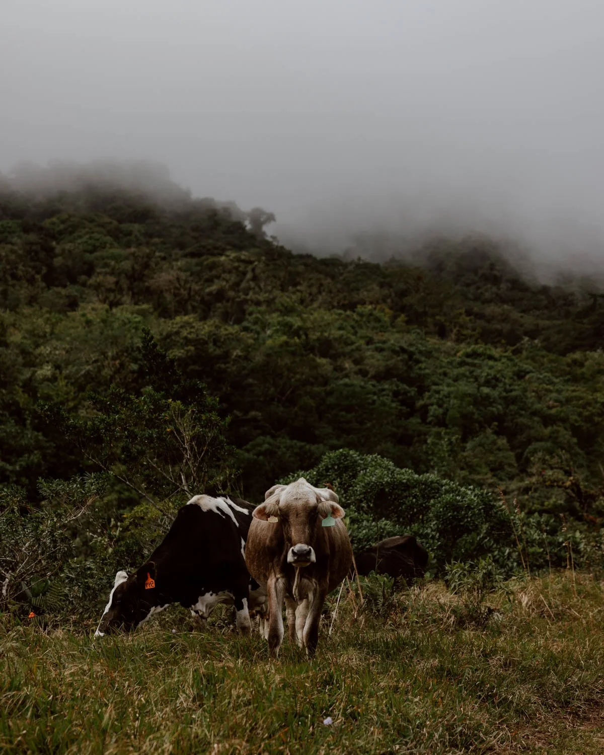
Whichever way you go, you’ll continue along a dusty (or muddy) rocky track that, paired with the highland climate, really felt like somewhere back home in Britain. With soft-eared cows in the fields, wildflowers, and hills surrounding, it’s all very beautiful and bucolic.
It’s an easy, gentle incline along this track between the fenced fields, but the road is also used by 4x4s and farmers.
This section took us about 30 minutes at a slow pace.
Travel Tip / It’s a good idea to have a Google Map downloaded for Boquete, and we also used AllTrails for this hike and others in the region.


Going Up
Just under 2km from the start, there was a very, very muddy section of the road, before you verge left at the fork and into the forest.
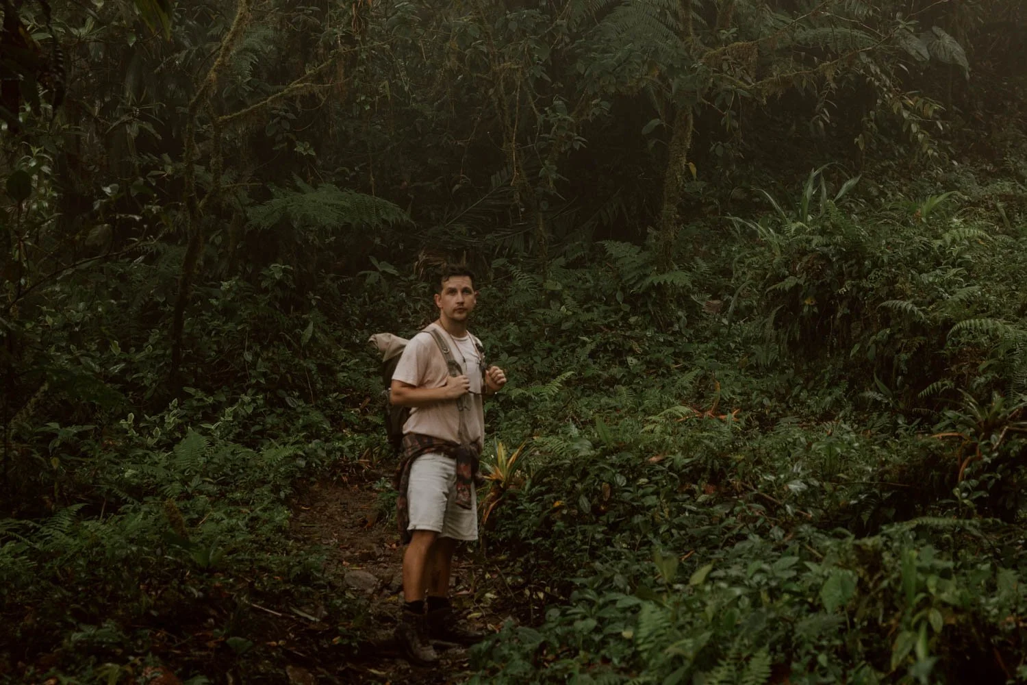
Once in there and under tree cover, the trail narrows, becoming a mixture of stones and rocks. It’s a pretty standard forest trail, but from here on in it’s going to be steeper.
There are then two forks after about 2.6km from the start (50 minutes or so), where it’s very very easy to go wrong / get lost:
The First Fork
Here, you need to go right and down towards the water, not left and up.

Once you’ve crossed the little babbling brook on the stones, you'll then see a very faint red arrow on a rock pointing up. Follow this and continue round on the stony rocky path, and you’ll emerge out where there’s a gate and some farmland.
Do not go through the farmland.
Instead, go left on the rocky trail with the big boulders for steps, which will take you up on a gradual incline.
None of the above is signposted.


The Second Fork
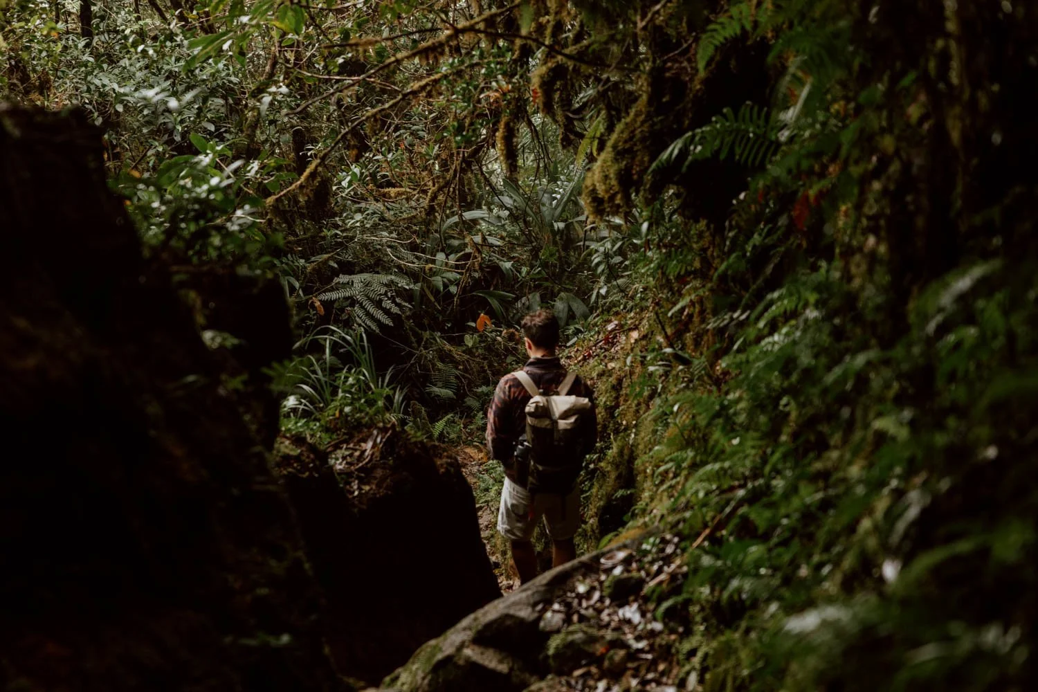
Not long after going left at the farm gate, the trail becomes very narrow and rocky, with high-sided rock walls of foliage and earth on each side.
After this, our phone’s GPS went haywire for the first time ever on a hike.
Eventually you’ll arrive at another point where there’s a clear trail going left, a clear trail going right, and no waymarker or signposts.
You need to go left.

We made the mistake of going right and down to the river first, and we met another couple straight after who did the same because their GPS had also gone squiggly. On the way back down, we bumped into another couple who were in the exact same spot debating (arguing) over which way to go.
So, for the avoidance of doubt, go left at the second fork.
Of course, this could all easily be fixed with a simple signpost. Indeed, given the history of El Pianista - especially the official verdict - it’s surprising that there’s such a lack of signage on the trail to avoid simple mistakes*. As the deaths of Kris and Lisanne are attributed to this area being impenetrable and easy to get totally lost in, surely the logical, responsible thing would be to add more signs to a popular trail?
Perhaps it was just paranoia from bingeing the Lost in Panama podcast the days beforehand, but it was quite eerie that our GPS on our downloaded AllTrails map went completely haywire for the first time in years of use (and that of the other two couples had the same issue with their own navigation apps).
After going left at this second fork, the trail narrows before emerging out to a wider opening where the sun finds gaps through the trees, and you realise just how high up you’ve walked since the start.
The feature that really marks this point of the trail though is the soft rock walls, which feel like they've been carved out by man (but are more likely natural channels for water flow during the rainy season). High-sided and covered in green shoots and moss, it’s only possible to go through them in single file.
For us, the final stretch up become quite a bit more squelchy and water-logged in parts. It was nothing to be concerned about, but if there’s been a lot of rain down the narrow rock channel, it may become quite treacherous.
*There are some rudimentary red arrows at a couple of intervals earlier on in the trail, but seem to completely disappear once you actually need them. We have heard that the authorities have tried to place more signs, but certain tour guides - presumably worried that they’ll lose business - keep removing them.


The El Pianista Mirador
We reached the summit of El Pianista two hours (5.5km) after leaving the car: if you don’t get a little lost like us or are more focussed on pace, you could probably trim 20-30 minutes off that.
At the top, you’ll find a small red and white cross dedicated to Lisanne Froon and Kris Kremers, along with one of the last photos taken of them.
This mirador is just a small clearing amongst the trees, rather than a large plateau or area where you can spread out, which was a bit disappointing to be honest. Our feelings were probably shaped by the fact that we were right in the clouds and had no view or visibility at all, which is the principle thing people do the hike for.
On a clear day, you’d be able to see out across the forested valleys and hills beyond.
From the mirador, there are also some (relatively obscured) faint trails that take you down in different directions: they do not lead you back to Boquete.
Anyone who has already read up of the Froon and Kremers case will know that they - intentionally or by mistake - took one of these, with multiple photos found on their cameras weeks / months later. These are listed on AllTrails and mentioned in blogs and podcasts - one is marked as the ‘Imperfect Plan’ route, the other is a more secluded path descending to a remote spot called Pato del Macho.
Some hikers and groups follow in their real or imagined footsteps out of curiosity, investigative zeal, or morbid interest.
Going Back Down
You should however return to Boquete along the exact same trail you came up.
Depending on your start time, the tendrils of mist may have grown thicker, giving the cloud forest a mystical, impenetrable appearance. This makes it important not to spread out too far from your hiking partner, as the visibility can reduce dramatically without warning, but the route down is self-explanatory.
Your knees may become a bit tired and achy, and watch out for slips and trips.
It took us a little under two hours to make it back to the car at a slow, steady pace.


The Realities of Hiking El Pianista
We wouldn’t usually include this section in our short hike guides, but think it’s necessary for El Pianista.
To this day, there are quite few people who haven’t been on the trail or anywhere near Panama, who seem to go on TripAdvisor and Google Maps to give a hyperbolic assessment, 1-star review, or warn others off. The podcasts and YouTubers we watched / listened to after falling deep down the rabbit hole also talked about the trail in a way that’s quite exaggerated - accentuating aspects which are very common to this and other hikes in Central America for dramatic effect.
As with any hike, there are of course risks if you continue beyond the summit on one of the unauthorised trails, get totally lost, or arrive unprepared.
However, beyond the lack of waymarkers leading to confusion at a couple of points and the GPS going haywire, the steep official trail up to the mirador and back down isn’t one we’d mark as particularly challenging or difficult. We say this having travelled and hiked in Central America for about three years all in.
That doesn’t mean the tragic, mysterious events that took place in 2014 don’t add a sense of unease at points and heighten one’s sense of paranoia.
Prep & Pack / Bring & Know
In terms of footwear, we think hiking boots are most appropriate. These are an essential for travel in Panama and Central America more generally, but for El Pianista, they’ll minimise the risk of injury and deal best with the mud and slick, slippy rocks. However, there were plenty of travellers on this trail wearing sports trainers. If they’ve got decent grip, they’ll do the job, but your ankles won’t have as much protection (and you definitely shouldn’t wear your favourite white pair).
In comparison to The Lost Waterfalls trail, this one suffers much less from mud but we really wouldn't want to do it in the rain or wet. If you’re traveling in rainy season, of there’s been a deluge the night before, perhaps reconsider your plans.
Once you overlook the wrong turns and lack of signage, we’d mark this as as an easy to moderate hike. Those who are less fit or mobile may struggle more on the ascent and descent, but the terrain and gradient won’t pose an issue for most travellers.
Hiking poles aren’t necessary, but if you’re travelling with a pair, by all means bring them along for extra stability and support.
As with all Boquete hikes, stick a rain jacket in your day pack, especially if starting later in the day (but we really recommend doing this one early).
This trail is used by local farmers and others, and you’ll likely pass some on your way up/down. A wave, a smile, and a ‘buen dia’ goes a long way.
If you ever find yourself asking - 'oh, is this a trail?' - then it almost certainly isn't.
There are no shops, so be sure to bring plenty water and snacks. We had our trusty Water-to-Go filter bottles, which we filled up in the river along the trail. They’re a great piece of travel kit that we’ve used for the last ten years, and you can get a wee discount if you use ‘ADR15’ on the official website.
Bring cash for transport, incidentals, and emergencies.
As mentioned earlier, we recommend walking or driving to nearby Altieri Specialty Coffee (maps) after you’re done, whilst there are a couple of other cafes nearby. For lunch, there’s also the conveniently located El Pianista Italian restaurant (maps)
A few other essentials to consider packing:
· Insect spray (we use plant-based, cruelty-free Incognito)
· Suncream
· A layer
· Fully-charged mobile phone


The Boquete Mystery
As mentioned, it’s very easy to fall down a rabbit hole on this, and one half of Along Dusty Roads did whilst we were travelling Panama.
There are roughly three competing schools of thought about the fate of Kris Kremers and Lisanne Froon: a hike that went badly wrong, an accidental death with suspicious circumstances and cover-ups, or something much more sinister involving local guides and gangs.
There are some wild theories alongside the more convincing alternatives to the official verdict, but a few things are clear to us:
something awful happened to two young female travellers far from home
the limited and confusing evidence available only raises more questions than answers
it’s a reminder to take hike conditions, preparation, and research seriously (which is exactly what you’re doing).
If you’re curious to understand more about what happened:
• The Lost in Panama podcast was our introduction - well-produced but glosses over key details and muddles timelines in places
• The Koude Kass blog is a very dense, meticulously researched deep-dive for anyone wanting a forensic account of the case
• There’s also this dedicated Reddit thread


