How To Hike Cerro La Silla in El Valle de Anton
The Cerro La Silla hike in El Valle de Antón is one of Panama’s most scenic trails, especially at sunrise.
In this guide, we’ve shared everything you need to know for the trail.

There are several excellent walks and hikes to choose from in El Valle de Anton, and we’d put Cerro La Silla up there as one that’s unmissable.
It should be considered as a manageable short, clearly marked hike to a fantastic hilltop view, rather than a full-on adventure or challenge. This means it’s accessible for all sorts of travellers as, whilst the setting and scenery dramatic, it’s not really that difficult to reach. However, those wishing to make it even more memorable should absolutely set the alarm early in order to get up to the summit for sunrise.
It’s up there with one of the best we saw during our month in Panama.
But, if a sunrise mission isn't in the pipeline for you, hiking the ridges of Cerro La Silla is absolutely still a worthwhile experience during the day or the honey light of golden hour.
In this short guide, we’ll share all the essential information you need to plan ahead for the Cerro La Silla hike, including how to get there from El Valle, where to park, entrances, route maps, and few travel better tips to give you the best experience on the trail.


The Cerro La Silla Essentials
What / Short but stunning out-and-back trail, it’s one of the easiest El Valle de Anton hikes
Distance / 3.5km total starting from official entrance (maps), but 6km total starting from the bus stop
Time / 90 minutes to 2 hours for the trail, but factor in transport / walk from town
Access / By car, public transport, or a 1.5 hour walk from El Valle
When / Best done for sunrise, but good all day and for sunset
Know / There’s no public transport available for sunrise hikers
Cost / $5 entry fee at the hut, cash only
Bring / A head torch, water fully charged mobile phone, and layers
Stay / Blasina Hostel + Bodhi Hostel
Plan / Our Guide to El Valle de Anton (tbc)
How To Get To Cerro La Silla from El Valle
The La Silla entrance and trailhead start is situated a 20-minute drive or 1.5 hour walk from the centre of El Valle del Anton - you can find it here on Google Maps. Once you see a big electricity station and pylons, you’ll know you’re getting close!
Note for the purposes of distances and times, we’ve taken the centre of El Valle to be the Mercado Central, but times/distances will vary based on which part of town you’re staying.
Those heading up for sunrise will have to walk, pre-book a taxi, or carefully drive their rental car, whilst anyone visiting later in the day can opt for public transport.
No guide or tour is required.
Public Transport & Walking
For sunrise hikes, you need to be organised as you only have two options.
A Taxi | This will have to be booked + confirmed the night before, and it’s probably best to arrange someone reliable via your hostel/hotel. Availability isn’t guaranteed though, and note that the taxis won’t go all the way to the trailhead start because the La Silla road is truly dreadful. Depending on the driver, you’ll either get dropped off by the El Roble bus stop (maps) on the main road - right next to the turnoff for the La Silla road - or 5-10 minutes closer if they’re willing to take you further up the La Silla road.
From the El Roble bus stop, it’s about a 1.5km / 30 minute walk to the trailhead start.
Unfortunately, we have no idea how much a taxi would cost, so do let us know in the comments if you take one!
Walk From El Valle | From the centre of town, it’s around 4km / 60 minutes to the El Roble bus stop and sunrise missions will have to do this under cover of darkness. As mentioned, if you’re staying further out in the western part of town, this distance could increase quite significantly so don’t forget to factor it in when working out wake up + departure times.
Most travellers go along the busy main road (Ruta Las Uvas - El Valle de Anton), but a guy at our hostel told us there’s a cut-through near a petrol station to avoid the main road and take a smaller, much quieter road up from town. Unfortunately, we didn’t make a note of the details, so feel free to share in the comments below to help out other travellers!
From the El Roble bus stop, it’s then 1.5km / 30 minutes to the trailhead entrance.
That means, in total, you should factor in about 1.5 hours from El Valle to the summit for sunrise, and to be on the safe side, a departure no later than 4.15am to be on the safe side for a 6am sunrise. However, please make sure to double check sunrise time, specific conditions and distances from your accommodation before finalising your own plans for the hike.
Also, be super cautious and pay attention at all times when walking along the roadside.
Buses | If you choose to hike Cerro La Silla later in the day, then you can walk simply jump in one of the frequent colectivos (small bus/van) from the town centre or main road to the El Roble bus stop (maps). That journey’ll take about ten minutes and cost you 50 cents.
Just ask for ‘El Roble’ or ‘La Silla’ and they’ll let you know if it’s the right bus.
As mentioned, from the bus stop you’re right on the turnoff for the 1.5km / 30-minute walk up the La Silla road to the trailhead.
Lastly, you’ll see bicycles and e-bikes available to rent all over El Valle, and whilst this could be a feasible option, we absolutely don’t recommend using them for a sunrise trip. You also wouldn’t be able to go all the way up the La Silla road with a bicycle.
Travel Tip // We wholeheartedly recommend the hostel we stayed at - Blasina - which handily happens to be on the right side of town for this trail! Two guys we spoke to actually walked it in just 45 minutes! If you choose to walk in the dark, please be responsible and bring a head torch and fully charge phone for light, and inform others of your plans.
Also, if you’re planning for sunrise but staying in a dorm, don’t be a dick and leave your prep until that morning. Instead, get everything ready the night before, set your alarm, and get out with the minimum noise in consideration of those sleeping.


By Car
We rented a car for half our time Panama, and it was ideal for accessing the various trails around El Valle de Anton.
We set off at 5.20am from Blasina, and it was a short drive in the pitch black up winding roads to the turnoff by the bus stop, where you’ll see a blue and white sign for Cerro La Silla. The first part of the road is pretty decent, but quickly becomes more potholed, bumpy, and rugged - and for sunrise you’ll be navigating it with just your full beam headlights.
There wasn’t much information online about vehicle access, so we had no real idea where to park. Thankfully we made an astute call not to continue beyond the electricity station as the road right after that to the trailhead entrance is ATROCIOUS and absolutely nobody should consider going down it with any rental car.
Seriously, it’s mostly craters and even if you own a 4x4, you'd really need to know how to use it - and we'd suggest you’re better off saving the suspension.
However, there are no obvious or marked parking areas along this road, and we recommend you take a right just before the electricity station and park up by the wall there. That’s what we did, and you can find the exact spot here on Google Maps. Should you park there too, get as close to the side as possible so as not to obstruct others, as the road is used for electricity station workers and vehicles.
From there, it was an easy 10-minute walk to the trailhead start.
If you miss that right, you are able to turn in front of the electricity station gate and double back - just don't be tempted to park there as there's a clear 'no estacionarse' sign (no parking).
Drivers who are more worried about their insurance deposit, a bit precious about the car, or only have low clearance, should absolutely park up much earlier on the La Silla road. Same goes if you're a more cautious or an inexperienced driver and this is where we suggest - just be sure to factor in more walking time, and ensure you don't park in front of someone's house or gate!
So, to summarise, you should give yourself 20-30 minutes for the drive from El Valle, and then 10-20 minutes to walk from your parked car to the trailhead start.
Plan / The Panama Driving Essentials (tbc)
The Trail
Going Up
However and whenever you’ve arrived, once you’ve passed the electricity station, it’s all pretty straightforward!
We walked with our headtorches along the gravelly, crater-ridden road to the official entrance point (maps), where there’s a proper sign and a slightly ramshackle blue hut. Given the hour and the remoteness, we were surprised when a lady with a strong American accent emerged in the dark to greet us with a good morning, and inform us that we could pay the $5 per person entry fee on our way back down.
This fee is legit, though was only recently introduced. It’s $3 for Panamanians, and cash only.
Note that the trail is officially open from 6am - 6pm, but you will have no issues if you head up before then (which is imperative for sunrise missions) or leave the summit after 6pm.
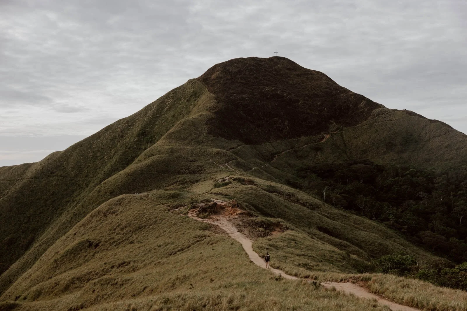
From the entrance, it's a gentle curving ascent on a clearly defined dirt trail. There's no real complications or ways to get lost - at the single fork on the way up, the left and right actually converge back to the same point, so it doesn't matter which you take.
At a brisk pace, it took us 10 minutes from the parked car to the entrance, then 20 minutes from the entrance to the summit.
There are two peaks: Cerro La Silla to the left with the cross is the highest, then there’s the slightly shorter hill topped by a beautiful Virgin Mary statue opposite. Both offer sumptuous, expansive views and photo opportunities, but we recommend going up to the cross first for sunrise or whenever you arrive.
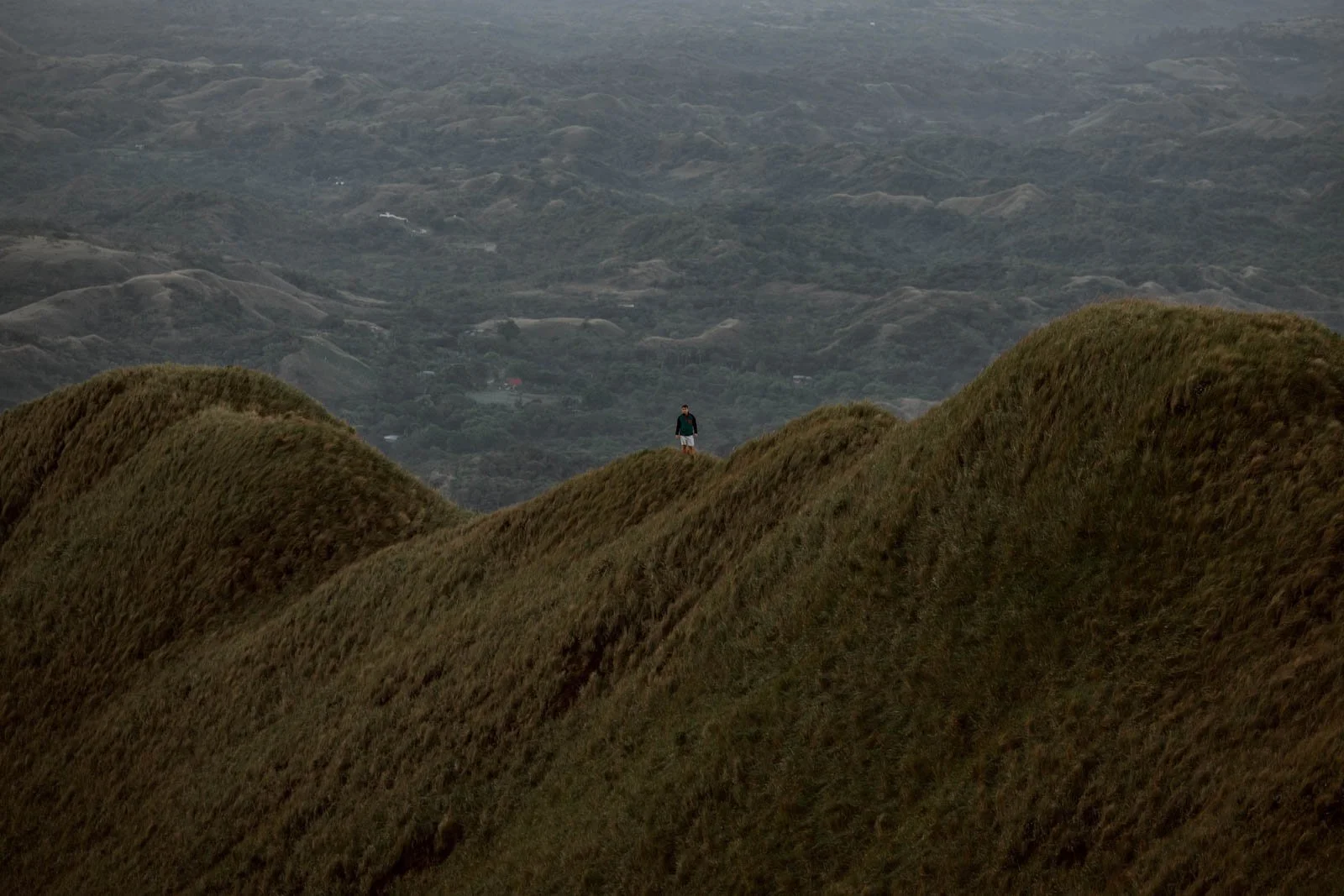
What you get up here is quite distinct from the crater rim hikes around El Valle, with rolling hills, trees, and crisp, clean air. We had never thought of Panama as such an abundantly green country, but this hike and El Valle made absolutely fools out of us.
Despite being able to just about make out the Gulf of Panama and a possible outline of Colombia, it all looked like a sunkissed Wales or Scotland.
By the way, one half La Silla looked to have been subject to a controlled burning not too long before our hike, which is why there’s quite a bit of black in our photos.
Maps & Apps // Unlike other trails in Panama, it’s not essential to have a map or route downloaded for La Silla, and there are a couple of wooden signs on the route. However, for reference or to help your planning, we’ve shared our own All Trails entry for Cerro La Silla.


Going Down
If you follow the route we and most others do, then it’s simply a descent back down along the same trail to the entrance hut. Sunrise hikers shouldn’t rush, as all of this will have been in the darkness on your ascent, and there are couple of excellent viewpoints
To return to El Valle continue to the turnoff / El Roble bus stop, from where you can simply walk back along the main road or hail a passing colectivo.
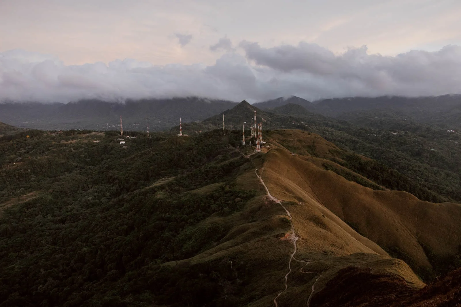
However, it is possible to turn Cerro La Silla from a straightforward out-and-back walk to a viewpoint into a longer, more challenging loop. This is accessed by following the narrow trail that’s visible to the bottom left when you’re atop the Virgin Mary hill. You can find this 11km loop on Wikiloc, but be aware that this does NOT lead back to the entrance cabin.
The American and British guys at our hostel who did the sunrise hike on the same day as us took this trail after seeing its outline on maps.me, assuming it would just loop round the hill and quickly back to the road. We saw back at Blasina much later in the afternoon, and learned of how much they regretted that assumption: they were both exhausted and relieved when a passing colectivo took them back to El Valle.
Now, the lesson here is obvious: never make an assumption on where a trail will go, especially when you haven’t got the right amount of kit, supplies, or energy to cover for the unexpected!
However, their regret isn’t guaranteed, and that longer loop may be a worthwhile option for some of you! If you do fancy it, just be certain to have a map or app with you as that narrow trail also forms part of a much more longer and more challenging 3+ hour crater hike from La Silla to Macano.
Travel Tip // However you get back to El Valle, we recommend heading for a hearty Panamanian breakfast of eggs, fried corn, plantains and black coffee at the great little Restaurant Massiel behind the market (maps).
Want to know what else to do after your Cerro La Silla hike? Read our El Valle travel guide.
Bring
There is absolutely no lighting on the road or trails, and our trusty headtorches proved to be essential (these are generally a great bit of kit to pack for all sorts of situations in Panama and Central America). If you don’t have one, your mobile phone will do the job as well, but just make certain it’s fully charged before you set off.
In terms of footwear, decent trainers will be absolutely fine if you’ve not packed your hiking boots - but you really, really should for Panama and Central America generally.
Beyond that, you’ll need some breakfast snacks, plenty water, and cash for the entrance and any possible colectivos back to town.
Sunrise hikers will definitely want to start the hike with an extra layer on top and below, but everyone should bring an extra layer due to the potentially windy conditions.
Safety
This is a short, manageable hike for most, and the trail shouldn’t pose any major concerns if conditions are good and you’ve taken the time to prepare.
However, there are obviously risks associated with heading out along a road and joining a trail in the early morning darkness, therefore we encourage solo travellers to try and find others at their hostel to join them for the La Silla sunrise, and always let someone you trust know your hike plans.