A Guide to La India Dormida Hike, Panama
One of the most popular activites in Valle de Anton, the India Dormida hike provides epic scenery - whichever route you choose.
In this guide you’ll find everything you need to know to hike it independently.
This is one of the most popular and easily accessible hikes from El Valle de Antón, the lovely town founded within the caldera of an extinct volcano just a few hours southwest of Panama City.
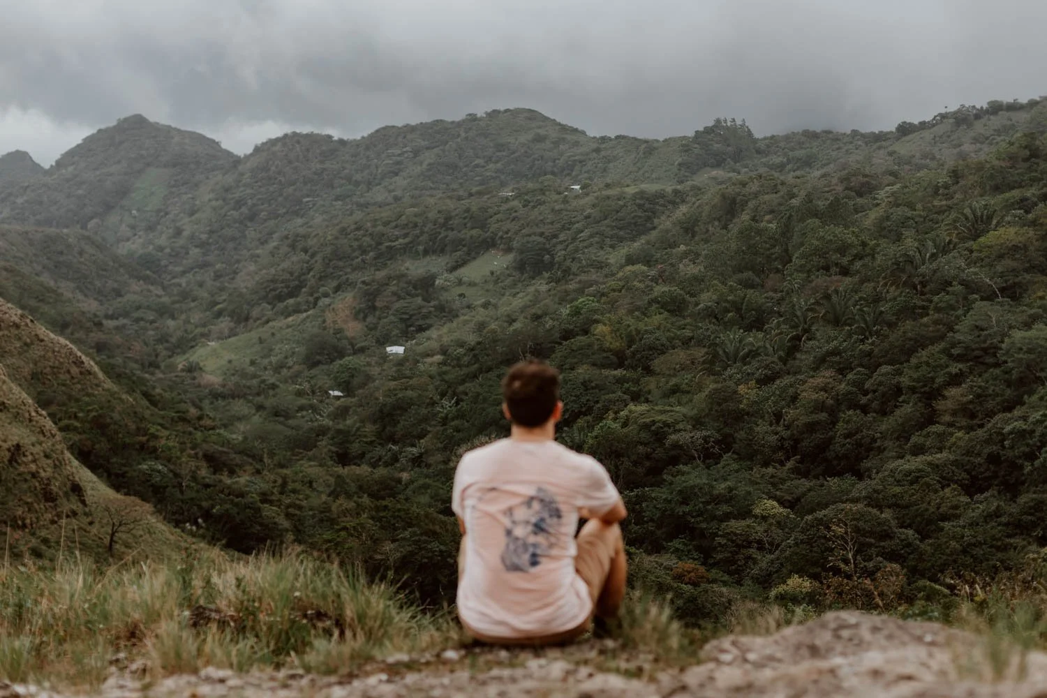
The India Dormida trail takes you up through thick tropical forest, past some small waterfalls and petroglyphs, and finally emerges out onto the signature windswept ridges and folds of the old volcano walls, offering fantastic views down over El Valle below.
The hike involves a bit of a scramble, and a mostly uphill climb to the peak of India Dormida, but it’s definitely worth it as an introduction to this gorgeous part of Panama, or as a final flourish to your time in town. It can be done a few different ways - as a loop, figure-of-eight, or a shorter out-and-back to the top - which permits you to choose the route to suit your fitness and itinerary, or choose to finish with a dip in natural pools. The descent on all routes requires a bit of care though, and a surer foot due to the potentially slippy conditions.
Those of you looking for a memorable morning should absolutely consider heading up there for sunrise.
In this short guide, we’ve shared everything you need to know to hike India Dormida in El Valle de Antón. From the three main routes, the entry costs, and tips for the trails, you’ll be able to plan ahead with confidence.
The India Dormida Essentials
Routes / Three options from El Valle
Distance / 3 to 6km, depending on route
Time / 2 to 6 hours, depending on route
Difficult / Moderate to medium, but slippy and scrambles in parts
Open / Officially from 8am, with last entry at 4pm
Prep / Sunrise hikers need lights and a clear route plan
Wear / Good footwear and a layer is essential
Bring / Plenty water and a snack or two
The India Dormida Hike | Three Options
There are a few different options for this hike floating around the internet and tourist information in El Valle, which can add unnecessary time and confusion to your planning. So, we’ve summarised the three main ones below for you.
All start at the Piedra Pintada entrance kiosk (here on Google Maps) with a $3 USD ticket, and pass by the petroglyphs, as well as the Chorro Los Enamorados and El Escondido waterfalls.
The Official Caldera Route | 4-5 hours | 6km | Moderate Difficulty
This one-way hike starts at the Piedra Pintada (Painted Rocks) entrance and ends down at Chorros Las Mozas, a series of natural pools and waterfalls which would be a wonderful way to end a sweaty hike.
The specific route actually isn’t listed on AllTrails, just this longer 16km option which encompasses most of it. However, this map on Wikiloc is almost exactly it.
The main point to note is that the official distance of 6km is point to point, and doesn’t include the extra 2-4 km you’ll have to walk from/back to the town before and after your hike.
Cerro La Cruz Loop | 2 hours | 3.5km | Moderate Difficulty
This follows the same trail as the official route, but descends a few kilometres earlier at ‘The Hill of The Cross’, ending back where you began at the Piedra Pintada entrance. Therefore, unless you re-enter for Chorro Los Enamorados, there’s going to be no waterfall dip at the end.
You can find the map + details here on AllTrails.
The Figure-of-Eight | 2 hours | 3.2km | Moderate Difficulty
This popular ‘out-and-back’ is the shortest and easiest option, with visitors turning back after reaching La India Dormida to descend + end back at the start point.
It’s the best option for those who just want to enjoy the views from the top of the mountain and have less walking.
You can find the maps + details here on AllTrails.
We opted for the Cerro La Cruz loop, purely because we’d planned to do several hikes in El Valle and it made most logistical sense to slot La India Dormida in on our the afternoon we arrived from Panama City. However, if we’d had a full morning or afternoon to play with, then we’d have gone for the official route with a dip at the Las Mozas waterfalls to finish - we visited these falls on our final full day in the area, and they were as refreshing as we’d hoped!
Sunrise Missions
Although we prioritised the sunrise from Cerro La Silla, La India Dormida is probably the more popular due to its ease of access from town when it’s still pitch black.
If attempting to be at the summit for sunrise, then you should also enter via Piedra Pintada as it’s the quickest and easiest route up. However, some of you will have noted that the ticket office is only open from 8am. Research tells us that you can still enter there for sunrise missions, but you may be asked to pay the $3 ticket on exit if you do the figure-of-eight route (or you can of course volunteer to pay it).
Rather than letting a $3 entry fee determine the time you hike, bear in mind that your walk up to the summit will be in darkness, so you won’t see the petroglyphs or the waterfalls if you continue on to Chorros Las Mozas.
Lastly, a headtorch is going to be very handy, but you could get away with a fully-charged mobile if you didn’t pack the former. You’ll also need to wear a layer to begin, and make sure to work out how long the walk is going to be from your accommodation to the entrance before setting your alarm.
To be on the safe side, give yourself 60 minutes from the entrance to the top.
Travel Tip // If you’ve only got time for a couple of hikes in El Valle, it’s worth knowing that Cerro La Silla is also a great sunset option.


Arrival & Parking
As mentioned, the start point for all routes is the Piedra Pintada entrance kiosk (maps), which is a 20-45 minute walk from El Valle depending on where you stay or start from. As with the other hikes in and around the town, it’s important to factor in this extra time and distance when planning your days as it can add up.
If arriving by car or bike, it’s possible to park for free on the road outside and just after the entrance. When we arrived in the late afternoon it was practically empty, but passing by a couple of days later it was chock-a-block with a couple of guys acting as parking attendants.
Do not try to park up on this road (maps).
You’ll see a big sign for the entrance, with few stalls lining the way to the ticket kiosk, where it’s necessary to pay $3 per person for a foreign adult and 50 cents per child. If entering after 2pm you will usually be requested to sign in when purchasing your ticket.
The official opening hours are from 8am, with last entry at 4pm.
Note that the large sign at the entry states ‘we recommend the use of a local guide to use the trail’. We really don’t think this is necessary, so don’t worry if you read this (it’s definitely not compulsory).
As Piedra Pintada is a well-known local attraction, thanks to its pre-Columbian petroglyphs and the two small waterfalls and creeks where locals often take a dip, you’ll encounter plenty of visitors who aren’t heading up to La India Dormida.Whilst we found the waterfalls a little underwhelming, the swirling remnants of a civilisation are quite distinct from other 'glyphs' we've seen and worth taking a moment to contemplate. Interpretations of these imposing carvings into the volcanic rock vary - perhaps a harvest calendar, a map about the river, or something else entirely.

The Trail Up
For the first few minutes you'll follow a smooth concrete path lined by houses, but you'll quickly be into the forest and the trail proper - the petroglyphs are near the start (maps).
After this the trail becomes a blend of rock, mud, and roots, and is essentially all up up up through dense tropical forest. We did this hike in January (technically the dry season, but there's always some wet spells in Panama), and this section was very slippy and unstable in parts, so it’s definitely not one for your favourite white trainers or anything without grips.
In wet weather, the slippiness would actually be quite dangerous and, for anyone doing the ‘figure-of-eight’ out-and-back, do be aware that you’ll have to descend this same steep, muddy section. Emily is quite certain she would have gone arse over tit at some point if we did that route, so watch your step!
Whilst the steepness can be very tiring, we found the humidity worse and sweated buckets despite the relatively short distance involved.
Just before the top, there a few more rock wall sections that require more of a 'climb' than a 'walk' to get up, but should be possible for most.
For this section, the trail is marked at various points with neon green arrows on grey posts, and it’s important to pay attention as the first few are easy to miss; when you see any of them with 'cima', that's the direction to follow.
At one point after Chorro Los Enamorados, the trail splits - you can go left for the top of La India Dormida or branch right. Both of these paths converge at the same point a little later, so stress about which to take.
It took us about 45 minutes to cover 1.7km and reach the top. This didn’t include any meaningful time at the waterfalls, which may be more impressive in the rainy season.


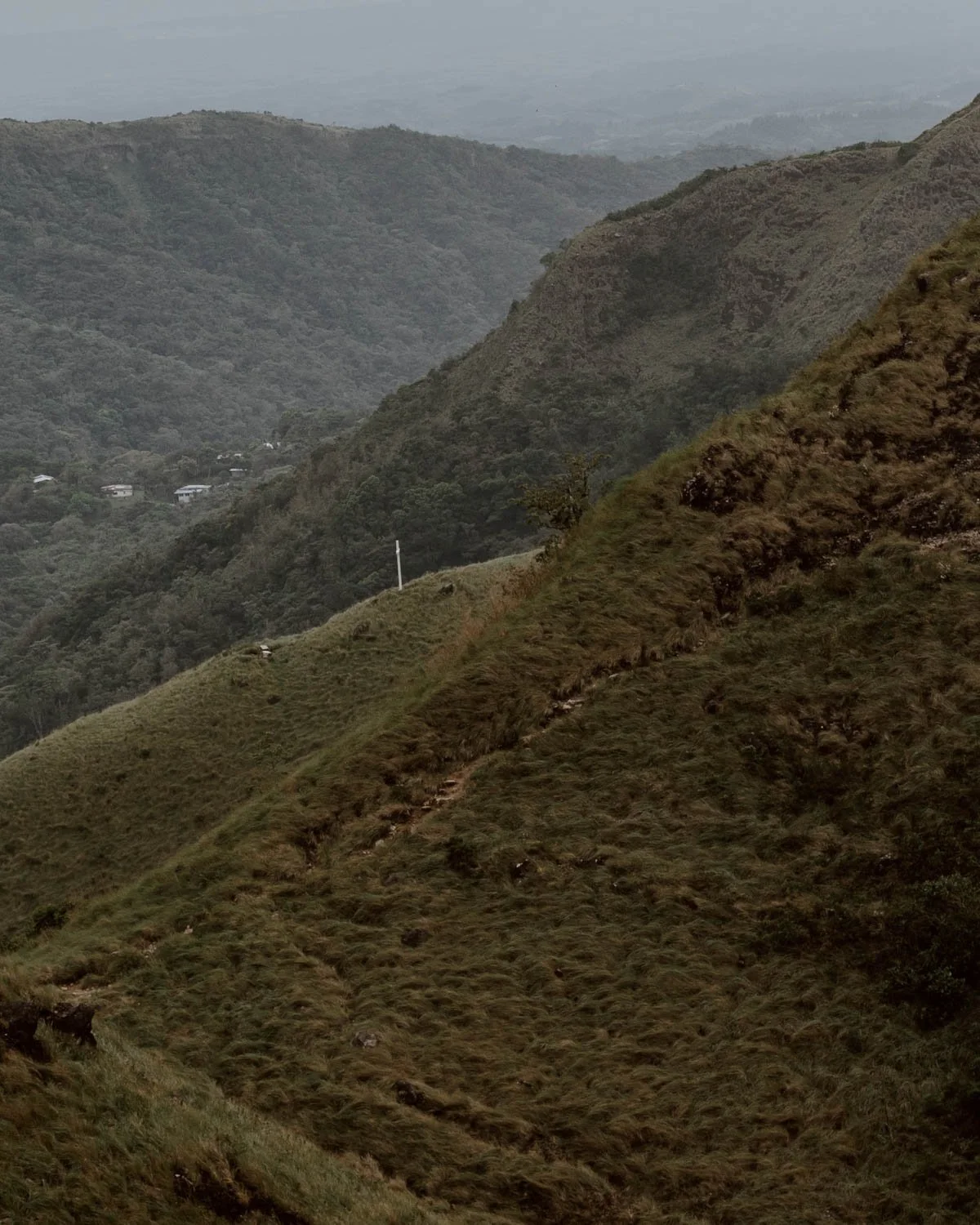
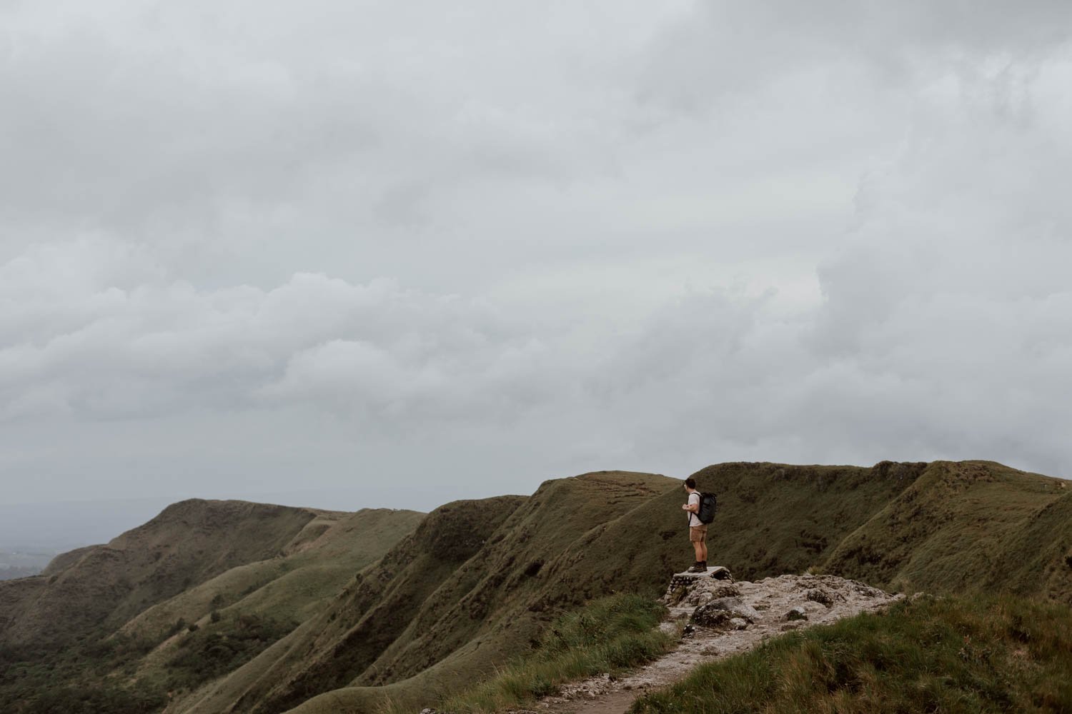
There’s a dramatic shift when the humid rainforest opens up and is left behind, and you emerge out on to the bare, open grasslands of the caldera rim.
As we’ve covered in our main guide to El Valle de Antón, all this was once a grand volcano a million years ago, and the town is situated in the deep basin left after the volcano collapsed in on itself after a series of eruptions. La India Dormida mountain is actually one of the remaining ‘walls’ of the ancient volcano.
Up on this section, you can enjoy great views in all directions, but it’s the scene to the left which is most captivating and context-giving; this was our first glimpse of El Valle, drenched in greenery and unlike any town we’ve seen before, spreading out through a massive forested basin with corrugated rooftops scattered among the trees.
This spot is the main India Dormida viewpoint that everyone’s heading toward and makes a good waymarker for your hike - find it here on Google Maps.
Take your time wandering along the rim to enjoy the flat trail and green surrounds; this is also the place to take a break or have your snacks on one of several benches scattered around.
Travel Tip // The India Dormida hike is part of El Valle’s new ‘Caldera Route’. Composed of approximately 30km of interconnected (and separate) trails along and around the mountain ridges and caldera rims, it includes three others trails which we cover in our main guide.

The Way Down
Once you’ve had your fill of the views, where you head next will depend upon your chosen route. Note, this going to be the section where travellers get a little lost or end up following a path they didn’t mean to take, so please make sure to pay attention to signs and your route map.
The ‘Figure-of-Eight’ | From the viewpoint you’ll take a right and follow a similar path back around and down, before rejoining the slippy trail and descending to the waterfalls and the entrance. Depending on how much of a sweat you’ve got on, a dip in the waters here may be exactly what you want (but note that Las Moza’s are bigger and more impressive)
Cerro La Cruz | Continue straight before taking a left down to Cerro La Cruz (The Hill of the Cross) which is marked by a small visible white cross. The trail down is pretty steep and poorly defined and whilst it feels like you’re going the wrong way at times, it absolutely does bring you out to the right place! You’ll eventually walk into forest, where the trail becomes much clearer, before entering a small alley and neighbourhood. When you hit the main road, go left and it will take you back to the start point.
La Moza | For this trail you’ll continue along the rim, followed by a descent to your left, and you’ll emerge out into the pools and waterfalls of La Moza. This is the official one-way route which is apparently marked by small grey signs / arrows. Unfortunately, we can’t personally confirm signage or terrain on the latter part of this section, but we spoke to a few hikers we met at La Moza a couple of days later, and they said it wasn’t anything too challenging. However, there are no ropes, rails, or markings once you reach the falls, and the only route is via a narrow path of slippy rocks at the water's edge; falling or slipping is a huge and likely hazard. You really do have to watch your step at all times, especially if you’ve got tired legs.
There are no lockers or storage facilities, but there’s plenty dry spaces on the rocks to store your bags and boots.
La Moza, by the way, is 100% worth visiting as a standalone activity in El Valle, and would be a wonderful end to this hike. However, do bear in mind that you may have to pay the $2 ticket when you exit.


What to Bring
· Irrespective of the which route you take, you’ll need to bring plenty of water with you on this hike. We were able to top up our trusty Water-to-Go water bottles (use the code ‘ADR15’ for a wee discount if you buy one - we highly recommend them!) at the earlier waterfalls, but given the most sweaty nature of the first big up, they were mostly depleted by the time we reached the summit.
· No real snacks or substance required, but the top would be a great spot to sit and enjoy something with the view (especially if you got up early for sunrise). The exception to this would be the La Moza trail when you will almost certainly need decent snacks / lunch.
· The wind can be quite strong, so brining an extra layer is essential
· If you’re planning on a dip in either of the waterfalls you can visit on this hike, pack your swimsuit and a travel towel
A few other essential we suggest packing include insect spray, suncream, some cash, headtorches (just in case), a fully-charged mobile phone and a battery pack if you have one.

Travel Better in Valle de Anton
13 Wonderful Things to Do in Valle de Anton